@inflect/map
Put a map of your PoPs on your website in 5 minutes, courtesy of Inflect.✨ Interactive demo and code examples
⚛️ Use React? We do too! Check out our React wrapper for this package.
Under the hood, @inflect/map uses Mapbox GL JS, and is compatible with browsers that support WebGL.
Installation
yarn add @inflect/map
</body> tag:<script src="https://unpkg.com/@inflect/map@1/dist/main.js"></script>Usage
Once you've installed this package, create an instance ofInflectMap and initialize it with your token and an existing HTML element's id. Make sure that your script or bundle has loaded first so that InflectMap is in scope.var map = new InflectMap();
map.init({
id: 'inflect-map', // The id of an HTML element
token: 'a1B2c3D4e5F6g7H8i9J0', // Obtained on your team page at inflect.com
});Required properties
Property | Description --------- | -----------id | String. Required. Default value: inflect-map.The
id of the HTML container the map should be inserted into.
token | String. Required. No default value.Your map token obtained at inflect.com. See Creating a map token for more information.
Basic properties
Like the required properties, these optional properties can be passed into theinit instance method.Property | Description --------- | -----------
autoCamera | Boolean. Optional. Default value: true.When
true, the map viewport will automatically move to fit the bounds of the source data.
cameraDuration | Number. Optional. Default value: 1000.The number of milliseconds it takes to move the map viewport automatically. When
autoCamera is false, this property has no effect.
dotBorderColor | String. Optional. Default value: #fff.The border color of the circular map markers. The value can be represented by any valid CSS color representation (hex value, rgb, rgba, named color, etc).
dotBorderWidth | Number. Optional. Default value: 1.The stroke width of the map markers' border, in pixels.
dotColor | String. Optional. Default value: #6a7685.The main color of the circular map markers. The value can be represented by any valid CSS color representation (hex value, rgb, rgba, named color, etc).
dotRadius | Number. Optional. Default value: 6.The radius of the map markers, in pixels.
hash | Boolean. Optional. Default value: false.If
true, coordinates and zoom will be appended as the document location's hash, so when navigating through history (or refreshing the page), the map viewport will be retained. This is most useful when autoCamera is set to false, and when there is only one instance of the map on the page.
height | String. Optional. Default value: inherit.The CSS value of the HTML container's height. By default, it takes up the same height as its container. If specifying a pixel height, be sure to include the suffix, e.g.
500px.
lat | Number. Optional. Default value: 16.875.The latitude of the center coordinate of the map. By default, the map is oriented to be aesthetically centered.
lng | Number. Optional. Default value: 28.30438.The longitude of the center coordinate of the map. By default, the map is oriented to be aesthetically centered.
maxZoom | Number. Optional. Default value: 24.A number within the range of 0 (zoomed out) to 24 (zoomed in) that sets the maximum allowed level a user can zoom in.
minZoom | Number. Optional. Default value: 0.A number within the range of 0 (zoomed out) to 24 (zoomed in) that sets the minimum allowed level a user can zoom out.
scrollZoom | Boolean. Optional. Default value: true.When
true, allows the mousewheel to zoom in and out of the map. Disabling this can be useful to prevent the map from hijacking a page's scroll behavior.
static | Boolean. Optional. Default value: false.When
true, prevents pan and zoom events.
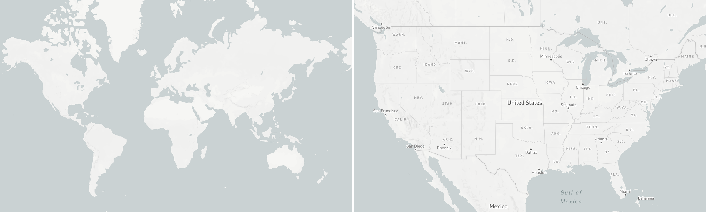
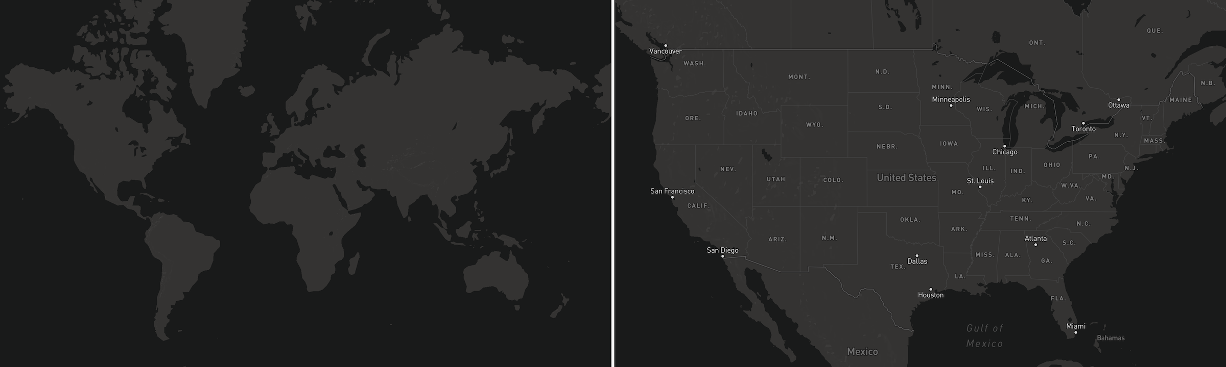
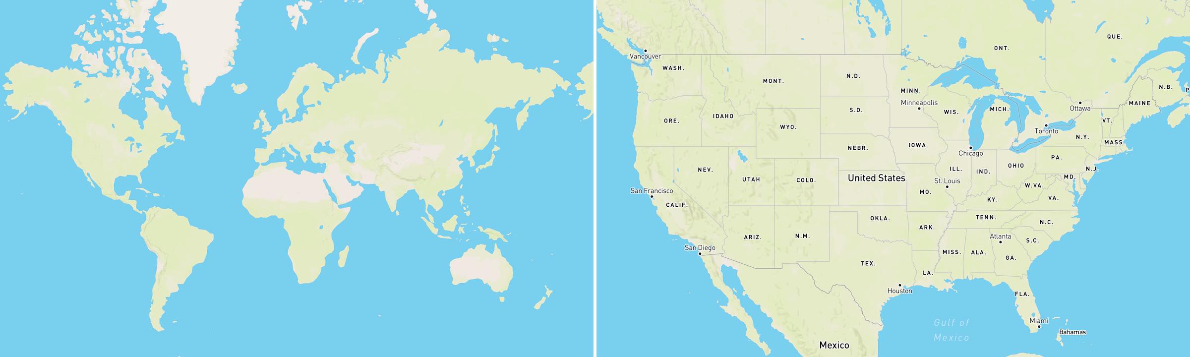
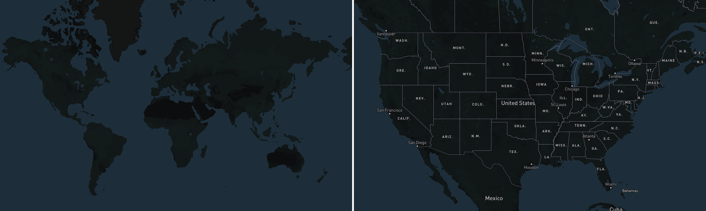
theme | String. Optional. Default value: light.The map theme. The value can be one of the following:
dark, day, light, night, satellite. See Themes for examples.
width | String. Optional. Default value: inherit.The CSS value of the HTML container's width. By default, it takes up the 100% of its container. If specifying a pixel width, be sure to include the suffix, e.g.
500px.
zoom | Number. Optional. Default value: 0.A number within the range of 0 (zoomed out) to 24 (zoomed in) that sets the current zoom level.
Advanced properties
Property | Description --------- | -----------onClick | Function. Optional. Default value: none.An event handler that fires when the map is clicked. If any dots are underneath the mouse cursor on click, they will be passed into this function. This function should take an array of GeoJSON features as a parameter.
onHover | Function. Optional. Default value: none.An event handler that fires when the mouse cursor moves over the map. If any dots are underneath the mouse cursor on click, they will be passed into this function. This function should take an array of GeoJSON features as a parameter.
onLoad | Function. Optional. Default value: none.An event handler that fires when the map has finished loading.
onMoveEnd | Function. Optional. Default value: none.An event handler that fires when the map finishes a pan or a zoom. The map event object will be passed into this function.
Creating a map token
- Create an account on inflect.com, or log in if you already have an account. If your company has already created a team, ask one of your teammates to invite you to join the team.
- On your team page, click the "Team maps" tab.
- Click "Create a new map".
- Select the data point(s) you'd like to embed on your site, and click "Create map".
- Use the resulting 24-character alphanumeric string as your
tokenwhen you init the map.
Styling
Themes
Below are values you can pass to thetheme property.light (default)
dark
day
night
satellite
Popup
You can override the default styling of the map popup by targeting the.inflect-map-popup class in CSS.Updating values
Callingmap.set() with any properties will update the map.This is useful if you want to cycle between a couple map tokens — calling
map.set({ token: newMapToken }) will load the new set of data and animate to its bounding box automatically.Potential gotchas
CSP Directives
As a mitigation for Cross-Site Scripting and other types of web security vulnerabilities, you may use a Content Security Policy (CSP) to specify security policies for your website. If you do, Inflect Map requires the following CSP directives:worker-src blob: ;
child-src blob: ;
img-src data: blob: ;
connect-src https://*.tiles.mapbox.com https://api.mapbox.comServer-side rendering
The dependencies of this package prevent it from being rendered server-side in node environments. As a workaround, import the package dynamically, or prevent the importing of the package in your build phase. If you have any troubles, please open an issue.iframe
We also host a page that you can embed via iframe. While we highly recommend installing the package instead, you can choose to embed an iframe version on your website if you so please. Just be aware of the following caveats of using an iframe:- You cannot dynamically set properties without reloading the entire iframe
- You cannot specify custom CSS for the map popup
- Advanced properties are not supported
Required and basic properties listed in Usage are available to the iframe as query parameters. Since the values are read from the URL path, you must URL-encode special characters (for example, when passing in a hex color value, you must convert
# into its URL-encoded representation %23, in order to avoid the value being interpreted as a document fragment).<iframe src="https://embed.inflect.com/map/1/?token=YOUR_TOKEN_HERE" width="100%" height="500" frameborder="0"></iframe>